Sources for Neighborhood-Level Boundary Maps and Crosswalks between Census Tracts and Neighborhoods
Boston, Massachusetts (Neighborhoods)
Boundary map source: Analyze Boston
Tract-to-neighborhood crosswalk source: Census Reporter neighborhood data files*
Chicago, Illinois (Community Areas)
Boundary map source: City of Chicago Data Portal
Tract-to-neighborhood crosswalk source: Census Reporter neighborhood data files*
Denver, Colorado (Statistical Neighborhoods)
Boundary map source: Denver Open Data Catalog
Tract-to-neighborhood crosswalk source: Census Reporter neighborhood data files*
Los Angeles, California (Neighborhoods)
Boundary map source: City of Los Angeles Geohub
Tract-to-neighborhood crosswalk source: Census Reporter neighborhood data files*
New York, New York (Neighborhood Tabulation Areas)
Boundary map source: NYC Department of City Planning Mapping Portal
Tract-to-neighborhood crosswalk source: NYC Open Data
Philadelphia, Pennsylvania (Planning Districts)
Boundary map source: Open Data Philly
Tract-to-neighborhood crosswalk source: Delaware Valley Regional Planning Commission
Phoenix, Arizona (Urban Villages)
Boundary map source: City of Phoenix Mapping Open Data
Tract-to-neighborhood crosswalk source: Census Reporter neighborhood data files*
San Francisco, California (Analysis Neighborhoods)
Boundary map source: DataSF Open Data Portal
Tract-to-neighborhood crosswalk source: DataSF Open Data Portal
Seattle, Washington (Community Reporting Areas)
Boundary map source: Seattle Open Data Portal
Tract-to-neighborhood crosswalk source: Seattle Open Data Portal
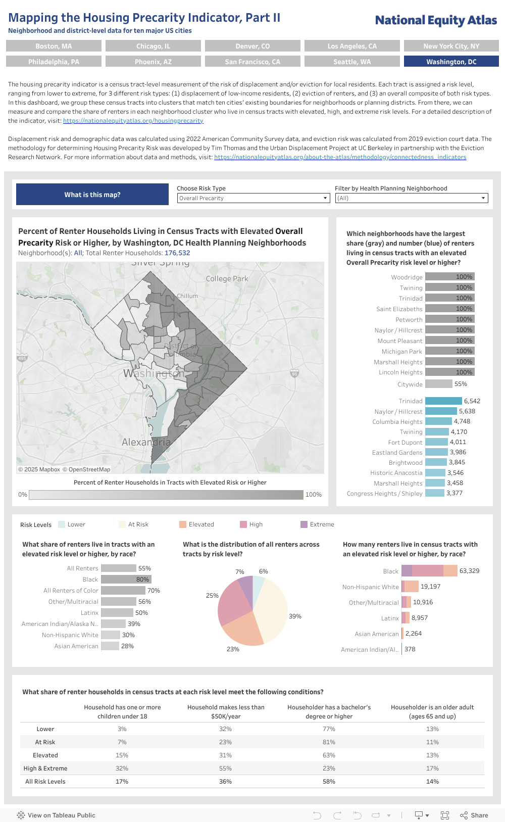
Washington, District of Columbia (Health Planning Neighborhoods)
Boundary map source: Open Data DC
Tract-to-neighborhood crosswalk source: Open Data DC (2010 Census tract boundaries)
2010 to 2020 Census tract crosswalk: Census Relationship Files
*Census Reporter neighborhood data files provide an approximate relationship between neighborhood boundaries and census tract boundaries, but in some cases a single census tract will fall between multiple neighborhoods. In those cases, the tract is assigned to the single neighborhood with the largest number of residents living in that census tract, and its residents are not counted in the data for other neighborhoods.